Above 4,100 meters, the air thins. The sun feels distant. At the edge of change lies Zorkul, a glacial lake perched on the Tajik–Afghan border, held in place by steep ridges and ancient ice. The Zorkul Reserve stretches across this boundary, a place where rivers begin, skies widen, and life clings in delicate communities. To walk there is to witness how geography, altitude, water, and life meet at the edge of survival.
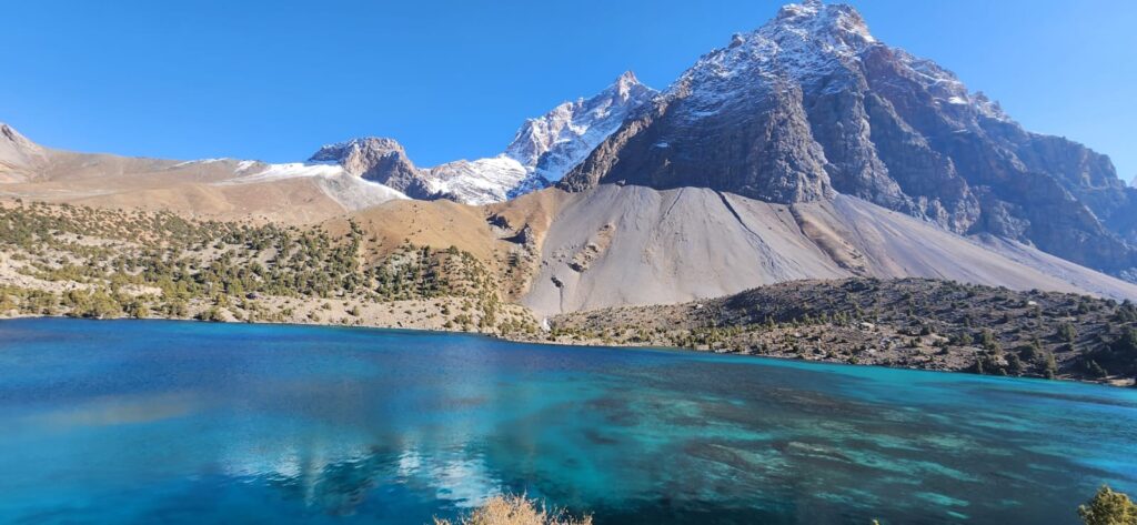
You arrive by winding track, crossing alpine meadows and rocky passes. Above each turn, ridgelines bleed into the horizon. Then the land dips and you see a mirror of sky, which is Zorkul spreading out like liquid light. Islands float near its center. Water feeds into a river that departs westward, beginning the journey of the Pamir River, which will become part of the great Amu Darya. The lake is a cradle of waters. The border lies along its southern bank, the Afghan Wakhan across the ripples.
Zorkul is protected- first as a zakaznik in 1972, later upgraded to a nature reserve. It is an Important Bird Area (IBA) under BirdLife International, holding some 110 species of birds, including bar-headed geese and migratory waterfowl (BirdLife/IUCN). The lake supports scarce fish such as false osman, Tibetan loach as well as alpine meadows ring the shoreline. Mammals move the slopes: Marco Polo sheep browse, snow leopards prowl, pikas dart among rocks.
Local shepherds move their flocks into these high pastures each summer. Though grazing is legally restricted within the reserve, in reality the meadows near Zorkul see seasonal use. A pastoralist says quietly, “The land up here gives us our summer pasture. We walk our sheep to water and grass. Without it, our herds suffer.” That use is woven into the reserve’s identity and tension.
Zorkul occupies a threshold of elevation, water, and state. It is where ice meets grass, lake meets sky, wildlife meets human presence. The altitude puts it at limits of life’s endurance; yet life persists in cold winds, shallow soils, and freezing nights. To live with Zorkul is to live at the margin of possibility, where every pond, every rock, every sedge matters.
Climate is fierce. Winters stretch long with temperatures plummeting well below –40 °C. Summers are brief and cool; July averages hover near 13–14 °C. Precipitation is rare; moisture comes mainly from snow and glacial melt, making the lake’s inflows seasonal and variable. In that dryness, the lake acts as regulator in collecting melt, releasing it slowly to feed the river.
Geography shapes the lake’s boundaries. The basin lies between ridges, collecting runoff from cirques and small glaciers. The lake depth is modest; shallow zones freeze solid or become marshy in warmer months. Along its edges, sedges, alpine meadows, and cushion plants colonize the margins. In seasonal springs and channels, cold‐resistant grasses and wetland species persist. Much vegetation is sparse, wood doesn’t grow here. Instead, low shrubs, cushion plants, sedges, forbs adapt to thin soils.
In 2012, a biodiversity survey recorded 119 bird species in Zorkul, adding new records like upland buzzard and black stork. Marco Polo sheep numbered over 1,500 in the area. Camera traps in the Wakhan region captured snow leopards and notably, cubs removing a camera in playful curiosity. Small mammals such as marmots, pikas, voles, all cover the scree zones. Amphibians and reptiles are rare or absent at this altitude.
But the reserve is under pressure. Remoteness gives illusion of protection, but enforcement is thin. Fuelwood gathering, illegal timber, and pasture intrusion erode edges. A management plan notes habitat degradation from human use at borders. Grazing competes with wildlife. In a 2018 study of the region, researchers found livestock in many areas reduce habitat use by ungulates, though carnivores remain less sensitive (probably because they roam broadly) (Karimov et al., 2018). That pattern underscores geography’s tension: animals and herds share slopes, and slope ruggedness, distance from camps, and resource patches mediate that sharing.
As waters depart the lake’s west end, the Pamir River begins its flow. Outflow proportions shift seasonally- when melt is intense, the river swells; when drought grips, flows shrink. The hydrological geography of Zorkul anchors downstream valleys. Communities lower down feel its seasonal pulse- irrigation, fields, drinking water.
Mapping Zorkul is a challenge. Satellite images pick out the lake shape, glacier patches, and snow cover. But fine distinctions like wet meadows, narrow channels and seasonal wetlands require field validation. The combination of digital elevation models, remote sensing, and local knowledge offers the best map. Historical maps also show that the glacial extent feeding the lake was larger decades ago, suggesting retreat. Though climate and hydrology models of the Pamirs confirm glacial loss trends, Zorkul’s basin is a particularly sensitive gauge, even small changes upstream echo downstream.
Crossing the lake’s border is metaphorical. The Afghan side lies across water. Historically, boundary commissions in the nineteenth century placed pillars along its southern edge, defining empire borders. But nature ignores those lines- water flows, birds fly, snow falls all across. Zorkul is a transboundary ecosystem. Conservation must also cross lines. In recent years, projects have aimed to manage biodiversity corridors linking Zorkul with Tajik National Park, engaging both conservation authorities and local communities.
Even here, microclimates matter. Slopes facing the sun warm earlier, loosening soils. Shaded slopes hold snow longer, feeding late meltwater. Wind scours exposed ridges, depositing dust on ice. The edges of lake ice melt first near inflows. Each meter of elevation, each exposure, shapes life’s patterns.
Walking along the pebbled shore, you see footprints of perhaps birds, perhaps humans- tracing edges. The water laps gently, cold, boundary, mirror. Mountains reflect in its surface; clouds drift overhead. In that moment, you sense that Zorkul is not only a place, but an idea: of boundary, of fragility, of life pressed to altitude’s edge.
To protect it is to protect a threshold landscape where water, climate, life, and culture intersect. The reserve is a geography of limits, but also of connections. It is water born in heights, life stretched across altitude, animals moving through passage, and people living with altitude’s challenge. Zorkul’s story is one of survival at the edge- its future hinge point for ecosystems and communities linked by that water, that slope, that fragile lake.
References
- Diment, A., Hotham, P., & Mallon, D. (2012). First biodiversity survey of Zorkul Reserve, Pamir Mountains, Tajikistan. Oryx.
- BirdLife International. Zorkul Nature Reserve IBA profile.
- ICIMOD. Zorkul Nature Reserve – habitat degradation & biodiversity challenges.
- Karimov, K. et al. (2018). Responses of snow leopards, wolves and wild ungulates to livestock and terrain in Zorkul region.
